Monday 30 October 2017

disappearing world #5

It had always been my intention to continue my Disappearing World series once I’d returned to Hong Kong, but I hadn’t expected to start with the subject of this post. However, I visited the village of Nga Yiu with Paula on Saturday because we’d heard that a disused brick kiln thereabouts was now a roost for several hundred fruit bats (Nga Yiu is less than a kilometre east of Muk Wu, which was the subject of the first post in this series).

We didn’t find the kiln, but I couldn’t help but notice what appeared to be a traditional watchtower that was festooned with creepers. It had to be worth a closer look.


This is the view from the opposite side (because of the vegetation, it isn’t possible to take a meaningful shot from further away):


There is also a sign on this side of the tower warning people that if they choose to enter, they do so at their own risk (the sign is only in Chinese). The only way into the tower is from an adjoining single-storey building, and the next two photos show all too obviously the reason for the warning. The first was taken from outside and the second from inside the annex.


The floors and staircases of the tower itself were clearly made of wood, but they have now rotted away or—more likely—been eaten by termites. The only illumination is via tiny windows (three on both the first and second floors, one on each of three sides; there are no windows on the ground floor) and what would once have been a door onto the roof. I could therefore take the final two photos only by using flash.


In other words, this tower, which I surmise once served a defensive function in more lawless days, is now a ruin. I wonder how long it will last before falling down completely.

other posts in this series
Disappearing World
Disappearing World #2
Disappearing World #3
Disappearing World #4

Friday 27 October 2017

ch-ch-ch-ch-changes

Ch-ch-ch-ch-changes
(Turn and face the strange)
Ch-ch-changes…
David Bowie, Changes.
Since 2006, I’ve spent the winter months in Hong Kong and the summer months in my home town in the UK. And every time I return to Hong Kong, Paula asks me whether I can spot what has changed during my absence. Hong Kong is always changing, but there seem to have been more changes than usual this year. This is an account of some of the more striking changes I’ve noticed this time.

It was dark when I got back to Fanling last Friday, but as usual our plan was to cycle along the frontier road on Saturday. During my absence, streetlights had been erected at 15–20-metre intervals along the entire length of this road:


This road was part of the ‘closed area’ until 2013, and it had always been illuminated by floodlights—also visible in the photo—to deter illegal immigrants. Consequently, this strikes me as a complete waste of money, unless, that is, they are no longer functional.

Having completed the frontier road, we then continued along the long and winding road, and it wasn’t long before I could see some apparent changes ahead. However, it was only when I was almost on top of it that I discovered a new rain shelter on the banks of the Sheung Yue River.


A short distance further, on a path described in Room for Improvement, I stopped to take the next photo. You will probably be wondering what is significant here, but note the whitish patch on the path. The concrete here was loose, and it would go ‘click! clack!’ as you rode over it. This is one of several such repairs that I’ve noticed while cycling this week.


After our Saturday bike rides, Paula and I always go to Sun Ming Yuen for afternoon tea, and on the way we have to negotiate the junction shown in the next photograph. I wrote about how this junction had been (badly) redesigned in The Design Floor, the problem being that when each of the four roads meeting at this crossroads has a green light, the other three are on red. However, a disproportionate amount of the traffic on the road on the left of the photo turns right, and a huge amount of traffic from the right turns left. Under the old arrangement, that traffic backs up to the next but one traffic light, which is clearly unsatisfactory. The change has been for this left-turning traffic to proceed at the same time that traffic in the opposite direction is turning right, making it even more awkward for pedestrians to negotiate the junction.


Incidentally, Paula wasn’t aware of the change here, partly because she doesn’t make a point of learning the sequence at any light-controlled junction. Given that I cross when I judge it safe to do so, not when the green man is illuminated, I was bound to notice this change.

Sun Ming Yuen doesn’t have any specials at weekends, but we also go two or three times a week for morning tea, and an innovation that I heartily approve of is shown in the next photo: smaller steaming baskets that hold just two rather than three or four dumplings. The photo shows a basket of two siu mai (minced pork, prawn and Chinese mushroom; my favourite) alongside a standard basket that held three char siu bao (steamed bread with barbecued pork in hoi sin sauce). The third bun is in my bowl.


Another important task on my first day back is to stock up with beer. I usually do this at the local branch of ParknShop, which when I left for the UK had a single entrance/exit. As you can see, that entrance now has a one-way turnstile, because the checkouts have been moved and a separate exit opened.


And the beer itself has also been the subject of change! My first choice is always Tsingtao, and in the past it has been sold at a variety of discounts. The nominal price is HK$14.90, but ‘buy three, get one free’ was common, as was three for $35.90. You can imagine my surprise (and delight) at finding it being offered at six for $60, which I’d never seen before. I took the following photo in the local branch of rival supermarket Wellcome (I’d gone in to check whether it was matching the ParknShop price, because whenever the offer price changes, there always seems to be some coordination/collusion between the two, which doesn’t make any sense).


An old man used to live in a hut at the beginning of the path between the edge of Fanling and where I live, and when he died or was rehoused, some enterprising artists decorated the hut to commemorate the fact that he kept a lot of cats (The Cat Man’s Hut). The hut has gone, although the cat farmer painted on the door can still be seen. This statue of a cat farmer appeared while I was away (the plaster pak choi is not new):


I’ve saved the best until last. My Sunday bike ride takes me through the village of Chow Tin, which I featured in Disappearing World #4. I took the photographs for that post back in May, and if you check the second photo in that post, all you’ll see is a blank wall. Now look at it!

Sunday 22 October 2017

favourite photos: summer 2017

It’s been a miserable summer in northern England. I’ve done very little cycling, and even though I’ve taken more than 900 photographs during the past five months, nothing I’ve taken has stood out. What follows is the best I could manage this summer.

I had intended to produce a companion piece to Mellow Yellow while I was in Penrith, but I couldn’t find enough yellow flowers. However, here are two local examples. I first wrote about ragwort in 2015, when I came across a plant that was infested with cinnabar moth caterpillars. This is a particularly large specimen of this poisonous plant, which I came across on Wetheriggs Lane:


Another stridently yellow plant is golden rod. I photographed this stand in the Thacka Beck Nature Reserve (note the pinkish flowers in the middle distance on the left of the path; this is rose bay willow herb):


The next photo was also taken in the Thacka Beck Nature Reserve. It shows a clump of purple loosestrife on the edge of the pond that is the centrepiece of the reserve. Other clumps can be seen on the far bank.


The next three photos were taken within the space of two and a half hours. The first was taken from my bedroom window at precisely 6am. It took three photos to get it all in, and I had hoped to stitch them together to form a single image, but the alignment wasn’t quite right. This is the middle photo of the three:


I took the second photo in this sequence at 7.43am, shortly after setting off on my morning walk. There is more cloud than in the previous photo, but the lineations in the clouds are still visible.


The third photo was taken at 8.26am from Castletown Bridge looking down Cromwell Road. I don’t know whether the two lines in the sky meet behind the hawthorn tree.


It’s a long time since I’ve seen a full, ground-to-ground rainbow, but this one was in front of me once as I walked down Thacka Lane to the nature reserve (the reverse of my normal morning walk):


Finally, I’ve included a photo of an oil stain. This one was more than a metre in diameter, probably because it formed under a parked car. Such stains when seen on open sections of road are invariably much smaller, perhaps as little as a single drop of oil.

Thursday 19 October 2017

a light-hearted question

I shall be heading back to Hong Kong later today, and as usual I have a puzzle to occupy your brain cells while I’m offline. However, It is not my intention to produce puzzles that no one can solve, so because my last puzzle (A Rotten English Question) remains unsolved, I’ve decided to post a much easier question this time.
What connects the following six clues?
● enthusiast.
● fruit.
● inundation.
● leader.
● location.
● quest.
Incidentally, this is what I call an ‘open-ended question’, meaning that I could have provided clues to additional entities that meet the connection criterion. However, six clues seems to me like an adequate number. Contrast this with An English Question (also unsolved), the solution to which is a complete set of five such entities. A sixth cannot be added.

I’ll be offline until at least Sunday, by which time I hope that someone will have submitted the correct answer to this puzzle.

Saturday 14 October 2017

a hard winter?

Most people will be familiar with the adage that a profusion of holly berries in autumn portends a hard winter. It’s nonsense, of course, but given that not only holly trees but also hawthorns are carrying massive quantities of bright red berries this year, it will be possible to evaluate the validity of this claim during the coming winter.

Clearly, there must be a reason for this phenomenon, but providing a food supply for the local bird population in advance implies some kind of conscious agency and can therefore be dismissed as a plausible cause for the greater than usual yield of berries. The real reasons for the bumper yield this year are the warmest spring in more than 300 years and a wetter than usual summer. Severe frosts in March and April kill off many of a tree’s flowers, and more flowers drop off in summer if it is too dry. However, in the last few days, hawthorn berries have begun to shrivel and are thus unlikely to be available as food when winter arrives. Although the profusion of berries, whatever the species, will have been the result of the same unusual weather conditions, only holly berries will be available as food in the depths of winter, which may be one reason for the erroneous belief that such profusion is the harbinger of a colder than usual winter.

Holly is the only common broadleaf tree in England that is not deciduous. In fact, holly has probably been associated with winter since pagan times because of this feature, and its red berries and unusually spiky leaves make it possible that it was believed to possess magical properties. The association of holly with winter was reinforced in more modern times with the introduction of Christmas cards in the mid-nineteenth century, and the sentimental juxtaposition of holly, snow and robin is still a popular motif for such cards. This association may even be the origin of the belief that the berries have been put there solely for the benefit of birds.

Here are two photos of hollies taken in the last few days. The first is of a holly in Castle Park; I took the second photo on Beacon Edge:


As I mentioned above, the local hawthorns, which are much more common than hollies, are also plastered with berries this year. Here are four recent photos; they could have been taken almost anywhere around Penrith:


Finally, here are two pictures of unidentified ornamental species. The first is of a tree next to the main railway line at the top of Brunswick Road; the second is of a bush at the entrance to a private house on Carleton Road:


Whatever the explanation for this year’s bumper crop of berries, and whether or not the coming winter is unusually severe, the local avian population will be well supplied with food.

Monday 9 October 2017

up to the mark

It all started with my morning walk. The beginning and end of the walk are fairly fixed, but I tend to vary the route through town. However, on most occasions I walk past Arthur Terrace, which is at the south end of Drovers Lane, and I remember noticing an Ordnance Survey benchmark somewhere in the area many years ago. As I walked past, I began to look out to see if I could spot it again. I didn’t stop, but my eyes scoured the walls and gateposts as I passed. It took me quite a few passes before I eventually saw it again. The first photo is of the general location, and the second is a close-up of the mark:


The horizontal line is precisely 133.4707 metres above mean sea level, as measured from a datum in Liverpool.

I knew of only one other mark, on the Beacon Tower overlooking the town, which is one of four grade I listed buildings in town. Technically, this is not a benchmark but a ‘bolt’ (the hole where the lines join contains a recessed metal bolt, although I have no ideas about its purpose).


The tower was built in 1719 to house the fires that had been lit on the top of Beacon Pike for centuries to warn the local population that yet another Scottish raiding party was on its way. When I was growing up, the tower was surrounded by steel railings, but when I came back to live in Penrith in 1989, I was surprised to find not only that the railings had been removed but also that the door was not locked. I was even more surprised to discover that there was a spiral staircase in the left-hand corner in the view above. The raised horizontal masonry course coincides with the upper floor, which is where the fires would have been lit, turning the tower into a gigantic lantern. The door is now locked, apparently in response to serious vandalism.

Anyway, I wondered if I could find any more benchmarks. I didn’t have much luck, but I did find two on Beacon Edge, the highest road in town. This is the entrance to Caroline Cottage, which was once the entrance to the public-access land surrounding the Beacon Tower:


I decided to try a Google search for ‘Penrith benchmarks’, and top of the search was a website that styled itself ‘Bench Mark Database’ (BMD). The members of this website log visits to benchmarks, and it so happened that one such member had been visiting Penrith benchmarks only two days earlier, which is why the site appeared at the top of my Google search. When I tried the same search the following day, the site was nowhere to be seen, but I found it again by consulting my recent browsing history, and by searching within the BMD website I was able to obtain a list of all benchmarks located within a 50km radius of my postcode. From this list, I learned that there were once no fewer than 87 benchmarks in town—this total includes ‘bolts’, ‘rivets’, ‘pivots’ and ‘flush brackets’—although 24 have been logged as ‘destroyed’.

I had expected that such benchmarks would be located where there was a good line of sight to the next one—hence my decision to look for examples on Beacon Edge—but when I obtained the list, I noticed immediately that several were in the town centre, and I’d probably walked past them many times without noticing them. Here are five such examples:

The Lowther Arms, Queen Street


Last Orders, Burrowgate


The former Old Crown, King Street


Sidney Bakewell’s old shop, Stricklandgate


Birtle’s Sports shop in Cornmarket


All these benchmarks have been painted over, which makes them harder to spot but still clearly identifiable.

I also expected benchmarks to be carved on buildings or substantial pieces of stone such as gateposts, so when I returned to Beacon Edge to check out Nandana, the former youth hostel, I couldn’t find the mark because I examined only the gateposts at the entrance to the house’s grounds. I returned after consulting the BMD website and found the mark cut into a boundary wall:


There is a benchmark that is even harder to spot on Bridge Lane, the main road out of town to the south:


This one is so inconspicuous that, having crossed the road to take a general picture of the location, I had trouble relocating the mark.

Finally, here are three benchmarks that I’ve walked past dozens of times this year alone without noticing them. The first part of my morning walk takes me through Thacka Beck Nature Reserve, on the northwestern outskirts of town, as far as Thacka Lane. The railway bridge over this road has a benchmark carved into the right-hand abutment (the approximate location is shown by the red arrow), and the second photo is a close-up of the mark:


The second example is carved into a converted barn at the top of the hill leading away from the far side of the bridge. The benchmark is located between the door and the drainpipe).


Both photos were taken looking back the way I’d just come to avoid shooting into the sun.

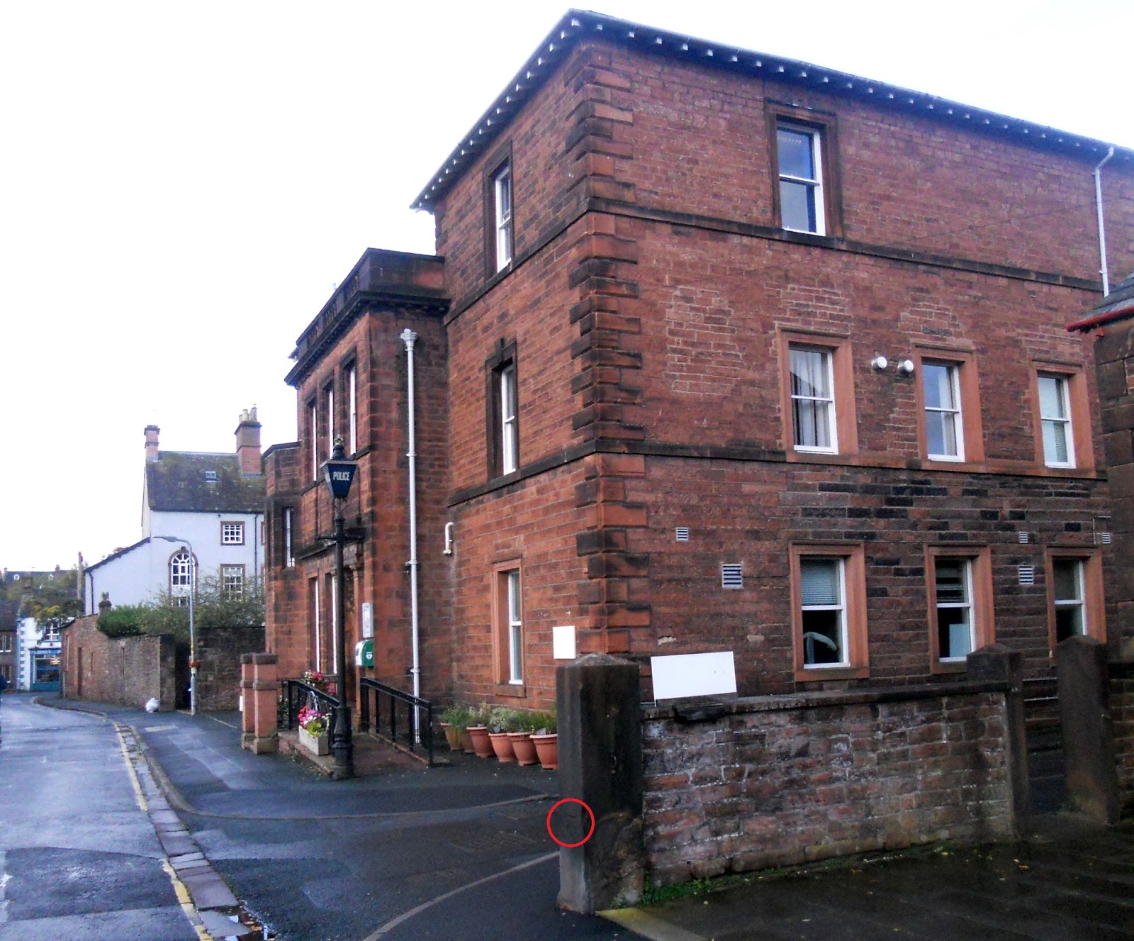
Although I usually continue straight ahead past Arthur Terrace, I do occasionally turn right down Hunter Lane at this point, meaning that I walked past yet another benchmark without noticing it. The large sandstone building is the police station, built in 1904, and Sidney Bakewell’s shop (see above) can be seen at the end of the road.


I’ve now located 53 benchmarks in Penrith, although as far as I’m concerned that is the end of the story. Nevertheless, it has been an interesting exercise that I feel was worth the time and effort involved.